About
An interactive view over a 2016 LAB-NET survey of ~106 medical facilities in Guinea — sample-transport routes, lab capabilities, and three measures of geographic access by rapid test type.
Facility locations are real surveyed sites. Survey response values shown in this public version have been randomized to protect respondent privacy.
How to use
- Click any chart bar or map cluster to filter — all other views update.
- Use the Capabilities chips to narrow by amenity or rapid test.
- The map overlay shows access burden by test type.
- Mouseover a facility to see possible sample-transport routes.
Reading the map
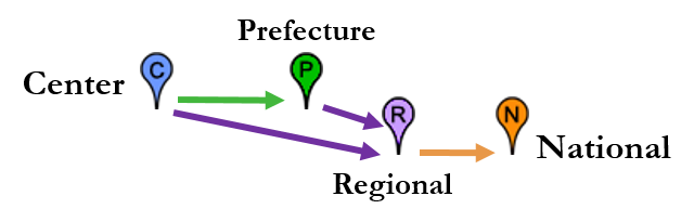
Markers cluster by administrative level — national (orange), regional (purple), prefecture (green), and center-level (blue).
Transport legend
Heatmap methodology
The three inaccessibility overlays were developed for the ASTMH 2018 poster Spatial Analysis of Health Facility Access in Guinea:
- PSU Applied Biological & Biosecurity Research Lab
Maciej Boni, Kory Blose, Stephen Fast, Robbie Fraleigh
- Fondation Mérieux
Siaka Ouattara, Moussa Condé, Marcel Yaradouno, Isabelle Amblard
- Guinea Ministry of Health & Public Hygiene
Mamadou S. Bah
LAB-NET partners: French Ministry of Foreign Affairs, Expertise France, Institut Pasteur. Survey collection by Fondation Mérieux. Route estimates from Google Maps.
This dashboard
Interactive layout, filtering, and web design by Robbie Fraleigh. Built with D3.js, dc.js (crossfilter), and Leaflet.
© 2018 The Pennsylvania State University · copyright info